Map: Plastic marine litter and waste fishing gear

Data preparation: Institute of Oceanography and Fisheries

Map preparation: Ministry of Economy and Sustainable Development

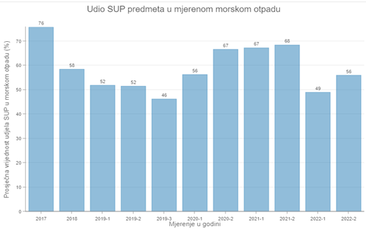
Plastic marine litter and waste fishing gear Map present data on single-use plastic items which are part of marine litter, and data on waste fishing gear.

The data was collected during the measurement of marine litter at 22 measuring stations, from 2017-2022. Waste on the beach, waste on the seabed, and floating waste from the sea surface were measured. The data were collected during the monitoring for Descriptor 10 (marine litter), prescribed in the Monitoring and Observation System for the Continuous Assessment of the State of the Adriatic Sea (Official Gazette No. 153/14).

The methodology applied for the monitoring of marine litter was prepared based on the recommendations of the EU MSFD TG10 „Guidance on Monitoring of Marine Litter in European Seas“, 2013.

Within the HRPWD Project, G-codes related to waste plastic items for single use (SUP) and waste fishing gear, were extracted from the total data on measured marine litter

More information is available in HRPWD Project reports.

Picture1

Map: Plastic waste recyclers

 Prepration of data and map: MINGOR, 2023

The map shows locations of plastic waste recyclers in the territory of the Republic of Croatia, who have a license for final recovery operation (R1-R11). Operators using only procedures R12 and R13 (which are not considered final recovery procedures, e.g. pretreatment, sorting) are not shown on the map.


Map: Separate collection of municipal plastic waste, municipality level

Preparation of data and map: Ministry of Economy and Sustainable Development, 2023

The Separate Collection of Plastic Waste Map shows data on certain plastic waste amounts separatelly collected (kilograms per inhabitant) in 2021, in each local self-government unit.

The map also contains data on the mass of certain plastic waste, the mass of separately collected municipal waste, the mass of collected mixed municipal waste, the mass of collected municipal waste and the rate of separate collection of municipal waste, for each local self-government unit.

Data on plastic waste refer to plastic waste that is part of municipal waste, and which is collected within the framework of public service and through bins placed on public areas.

The map does not show data on separately collected waste from service sector and waste collected within the framework of the national extended producer responsibility system organized by the Environmental Protection and Energy Efficiency Fund. It was not possible to accurately allocate collected amounts of this waste amounts to local self-government units. The map does not show data on plastic waste which is industrial waste.

The data source is Environmental Pollution Register (ROO) managed by MINGOR.

Map: Selected fishing landing sites, plastic waste bins

Prepration of data and map: MINGOR, 2023

The map shows 119 locations of the most important fishing landing sites (which are listed in the Order on the list of landing sites for landing catches from fishing vessels engaged in commercial fishing at sea, OG No. 53/22). Information about the available bins for separate collection of waste fishing gear / marine litter, or other plastic waste, is presented for each location.

Landing sites can function as a fishing part of a port open to public transport or as a port of special purpose - fishing port.

The data were collected by MINGOR in 2023.

According to the collected data, only 6% of landing sites have containers for separate collection of fishing tools or marine waste.